Results ordered by default filtered by
5 results matching your selection
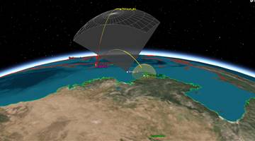
First of a planned 30-satellite constellation using radar imaging. Pathfinder.
X-band synthetic radar aperture microsatellite.
Radar imaging satellite. Can measure moisture in soil to 2 meters.
"Product of a public-private partnership between the British government, UK satellite-builder Surrey Satellite Technology Ltd., and Airbus Defense and Space, which supplied the mission?s radar imaging payload from its facility in Portsmouth, England."

.png)